


Bitter cold, snow gives Clinton first taste of winter

Local shoppers, in anticipation of the approaching storm, and the snow and bitter cold temperatures it would bring with it, all but emptied the bread and milk shelves from the Albany IGA, shown above, and the Save-A-Lot grocery stores, the two largest food markets in Albany.
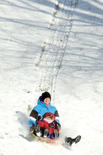
Despite the bitter cold, some residents ventured outdoors for some sledding fun anyway. At left, Leanna Oesterreicher and her daughter, Isabella, rode a sled down a hill at Memorial Hill Cemetery Monday morning.
Clinton County schools cancelled classes Monday, Tuesday and Wednesday.
The winter season of 2013-2014 is now just barely three weeks old, and already the residents have been through one of the coldest stretches seen in this area in some two decades.
Albany and Clinton County may have dodged the bullet, so to speak, in the amount of snow that was predicted to fall in this area when a winter storm moved across the region Sunday evening and into the early hours Monday morning, but we weren’t quite so lucky in dodging the frigid temperatures that the system brought with it.
While earlier predictions were that Albany and Clinton County could see between three and six inches of snow falling Sunday afternoon and evening, the system moved in a more northern direction as it approached this region, leaving less than an inch of snow on the ground here.
The severe cold temperatures that were predicted to accompany the winter storm system in this area were, unfortunately, correct.
After seeing high temperatures in the upper 50s this past Sunday afternoon, with sunny skies throughout most of the day, local residents awoke to frigid surroundings on Monday as temperatures dropped more than 50 degrees in a stretch of just 24 hours.
According to the weather and climate data gathering equipment near the Clinton County Middle School operated by the Kentucky Mesonet project of Western Kentucky University, at 1:45 p.m. on Sunday, January 5, a high temperature of 57.1 degrees was recorded, and the temperatures hovered in the 50s throughout most of the daylight hours.
As evening and nighttime arrived, along with a period of heavy at times rainfall, those temperatures began to quickly drop and shortly after 8:30 p.m. Sunday, the rain turned to snow as the very tail end of the storm system found its way into Clinton County.
At the same time, a blast of cold, arctic air that had been moving southeast across the Midwest section of the nation, met up with the system that had been producing the precipitation, and the snowfall event soon ended as temperatures continued to dive.
When local residents awakened on Monday morning, frigid temperatures outside were giving single digit readings.
The cold temperatures were blamed on a downward direction of cold air that moved across the nation that was referred to by weather experts as an arctic vortex.
At 5:30 a.m., temperature readings at the Mesonet site were 9.8 degrees and by 9:25 a.m. on Monday, those readings had dropped to just 2.5 degrees.
Although the clouds moved out of the area and sunny skies prevailed for most of the day Monday, mid-morning and afternoon highs never even reached the five degree mark.
According to data recorded by the Mesonet equipment, Monday afternoon’s high temperature did eventually reach 4.8 degrees at 2:00 p.m., which was about the time that temperatures once again began dropping in Albany as the sun started getting lower and lower in the horizon.
In preparing for Sunday’s arrival of the first harsh storm of the winter season, transportation departments for the state had pre-treated the main highways with a brine solution, and later, after the snowfall, state and local highway crews were applying salt chemicals as well as using scraper blades to remove the snow.
The combination of bitter cold temperatures and the snowfall forced school officials to call off classes in the Clinton County school system for Monday, Tuesday and Wednesday and planned basketball games on both nights were called off as well.
Clinton County’s boys’ basketball was scheduled to host Whitley County on Monday, and the girls’ team was originally set to travel to Casey County on Tuesday night.
No word from C.C.H.S. Athletic Director Mike Beard yet on when or if those games will be rescheduled.
A quick check of Albany’s two largest food retailers on Monday morning, Albany IGA and Save-A-Lot, indicated that local shoppers had been out in force on Sunday in anticipation of the approaching storm.
Supplies of bread and milk at both outlets were virtually wiped out when the two markets opened on Monday morning.
The frigid temperatures continued to grip the area throughout the day and evening on Monday, with highs never reaching above the five degree mark, and as the daylight turned to darkness, the system brought even colder temperatures to the area that evening and early Tuesday morning.
Although no additional precipitation fell in the area after Sunday’s snowfall, the storm did cause even colder temperatures to be experienced Monday night and into the early morning hours on Tuesday.
At 3:55 a.m. Tuesday morning, the coldest readings of the period were reported by the data collecting equipment at the Kentucky Mesonet site when 5.6 degrees below zero were recorded, at which time temperatures began a slow climb upward toward the zero degree mark once again.
The frigid temperatures were expected to gradually leave the region beginning Tuesday and Wednesday as the arctic blast moved northeast, loosening its grip on this region.
Forecasts for the area called for more seasonable temperatures and conditions for the next several days, with highs reaching the upper 50s by the weekend when rain was expected to reach the Albany and Clinton County area.