Storm damage is widespread

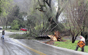
Raymond Shelton, right, placed a “SLOW” warning marker alongside the highway to alert approaching traffic to this large pine tree that was downed in front of his home on the Wisdom Dock Road after Monday afternoon’s storm. At left, Wayne Shelton watched for oncoming vehicles coming up Town Hill. An ambulance crew was positioned on the west side of the downed tree to give approaching traffic a warning about the hazardous situation.
A host of trees were destroyed in Monday’s storm, and several structures received damage ranging from total destruction to minor damage.
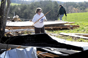
In the photo below, h\omeowners Michael and Carolyn Guffey spent most of Tuesday picking up debris after what was thought to be a small tornado came through Piney Woods and ripped a patio room away from their house.
Carolyn Guffey said no one was home during the storm and she felt very fortunate for that.
“We stayed at the school for a little while yesterday afternoon with the kids,” Carolyn Guffey said. “The storm probably came through around 3 to 4 p.m. Our neighbor, Albert Jones, said he watched it touch down from his storm cellar in the field behind the house, then it went back up and came back down on the side of the house. There used to be a trailer sitting here and in 1974, when the tornado came through, it wrapped the trailer around a tree.”
When the Guffey’s returned home yesterday afternoon,the were blocked from their home by a tree that had fallen across the road.
Efforts were made to remove the tree to allow safe passage, as well as temporarily repairing the side of their home to try and keep the rains from getting in.
School officials made a last-minute decision to hold students at the Clinton County Schools until the storm system had passed through the area, meaning that buses were delayed for about 30 minutes Monday.
Superintendent Mickey McFall noted that most parents who were at the schools to pick up their children, stayed at the schools with the staff and students in designated safe zones.

Backhoes, bulldozers, trucks, tractors and especially chain saws along with able bodies to operate that equipment were in tremendous demand Monday evening, throughout the night Monday and into the day Tuesday, as residents and crews across Clinton County worked to clean up the aftermath of a storm system that caused considerable damage here.
The line of storms hit Clinton County at about 3:00 p.m. Monday, moving from the west to the east, and producing torrential rains and high speed winds that caused damage to trees, utility poles and structures across the county.
At about 3:00 p.m., as the storm moved into Clinton County, the storm warning sirens were activated to give local residents the chance to seek cover from the approaching line of thunderstorms and high winds.
The most damaging part of the storm system had moved through in about 30 minutes, but heavy rains and some sporadic lightning continued well into the late hours Monday night.
Although official determinations won’t be made until later this week, at least one witness in the Piney Woods Community reported spotting a funnel shaped cloud that had “touched-down” and caused damage to a home owned by Michael and Carolyn Guffey.
The storm system hit Clinton County at about the same time Monday afternoon that local schools were getting ready to dismiss students for the day.
Students were held at the schools and buses were delayed until after the system had passed through the area.
Clinton County Schools Superintendent Mickey McFall told the Clinton County News that the dismissal was delayed about 30 minutes Monday, and he was very satisfied with how the procedure played out.
“It was kind of a last minute decision and just before 3:00 o’clock Monday, we received notice that we were under a severe thunderstorm warning,” McFall said. “We held the buses, and I think in hindsight, it was the right thing to do..”
McFall explained that during the process, which is part of a pre-planned procedure designed specifically for situations like the one that was experienced Monday, in addition to the students who are transported by bus being held, those students who are accustomed to riding home with parents, are also encouraged to stay inside the building as well.
“We encourage the parents to stay with us, and most of them did,” McFall said. “We just found a location for everyone to get into that is considered a safe zone.”
McFall said that the plan is designed to not only keep students and parents safe, but also helps to keep staff members from having to be outside of the designated safe zones in order to get students signed out.
“You don’t want to see the parents and students put in harms way, and the parent can be with their child, so it eases their minds as well,” McFall said. “By and large, it went very, very well with the parents and the students at all of the schools.”
Clinton County Disaster and Emergency Services Director Lonnie Scott spent most of Monday night out in the damaged areas, and then returned early Tuesday to begin assessing the reports of damage across Clinton County.
Although he was far from being ready to offer final numbers at press deadlines Tuesday, he did tell the Clinton County news in a brief telephone interview at mid-day Tuesday, that he was in fact finding very widespread damage.
“Unlike previous storms that have hit us, what I’m finding this time is a very, very scattered path of damage – it ranges from Lettered Oak to Sugar Valley to Piney Woods,” Scott said.
Scott said that by mid-day Tuesday, he had already worked reports on about 25 residences with various degrees of damage, and he estimated that the number of barns and outbuildings he had seen at that point that had been damaged was probably 50 to 60.
Although he had yet to make it to the Piney Woods area when he discussed the situation with the NEWS, he had also had one report of winds from the Churntop area that were moving in a direction other than straight.
“Georgie Armstrong called in and told me she had lost a roof off of a rent house she owned in the Churntop Community, and she told me the winds were moving in a ‘twirling’ fashion,” Scott said.
Scott also noted that he would be contacting the National Weather Service when he had completed his assessment work across the county to see if they wanted to send in an investigator to make a determination as to whether or not tornados had touched down in Clinton County.
Monday’s damaging storm system came exactly on the 37th anniversary of the series of tornados that hit this area on April 4, 1974, leaving a path of death and destruction in its wake.
Eight people from Clinton County were killed in those 1974 tornados and homes and structures across the county were destroyed and heavily damaged.
In the storm that hit here this past Monday, at it’s peak, winds were measured in excess of 53 miles per hour. Those measurements were taken at the Kentucky Mesonet weather facility located near the Clinton County Early Childhood Center just north of Albany.
In areas where excessive damage occurred, where “micro-bursts” were experienced, wind speeds in excess of that 53.6 figure were likely.
The system also produced 1.8 inches of rainfall as it moved through that same area, according to measurements taken at the facility Monday.
State, county and city road maintenance crews, South Kentucky RECC crews, as well as the Albany Fire Department and local law enforcement officers went to work immediately as the storm made its way across Clinton County leaving a path of damage behind.
A host of structures were reported to have received damage that ranged from minor to total destruction. One of the heaviest damaged buildings was a large steel building located in front of the Clinton County Area Technology Center just north of Albany on U.S. 127.
That structure was completely destroyed by the storm system. Several other structures, including homes, barns and storage buildings, were reportedly damaged by Monday’s storm.
Power outages, both short and long-term, were suffered across Clinton County as a result of Monday’s storm, with crews from South Kentucky RECC beginning work immediately after the storm moved through the area to restore power to local customers.
In a press release issued Monday morning, South Kentucky RECC spokesperson Joy Bullock, noted that the damage to power lines and poles had been extensive across the South Kentucky RECC service area.
“At peak yesterday, approximately 12,000 were without power,” Bullock said. “The high winds that accompanied this storm wreaked havoc on power poles and lines and caused trees to fall on the lines in every county of the South Kentucky RECC service territory.”
By early Monday morning, power had been restored to all but about 2,100 customers of the cooperative, and it was expected the process of having 100 percent of customers back in service would be completed by sometime Tuesday.
“Many outages had a great deal of damage, and it is taking quite a bit of work to get electricity restored to some,” SKRECC V-P of Engineering and Operations Dennis Holt said Monday morning. “We still have at least ten broken poles to repair. While we still have outages in all of our counties, many individual outages, the largest number without power is in Wayne County. It appears that restoration efforts should be completed today.”
With severe storm season in Kentucky continuing for several more weeks, Holt took the opportunity to remind local residents of the dangers of power lines and utility poles that have been downed during storms such as the one that was experienced Monday in Clinton County.
Holt said it is important for people to remember that a downed power line is not necessarily a dead line.
“If anyone sees a downed power line, they need to call us or 911 to report it,” Holt said. “It is important for them to keep others away from it until help arrives.”
Holt says that he and all the employees of South Kentucky RECC appreciate the kindness and patience from the members during these widespread outages and restoration.


