


Tuesday snowfall gives students earliest ‘snow day’ in at least 23 years
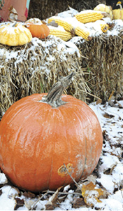
There was barely a few days between the first frost on the pumpkins, and Clinton County residents waking up to snow covered pumpkins, but that’s what happened here this week.
In the midst of frigid cold temperatures that arrived across the nation weeks earlier than normal, thanks to a weather system that resulted in a downward push of the jet stream and cold air moving in from the northern arctic circle, Albany and Clinton County residents awoke early Tuesday morning to yet another reminder that the winter of 2014-15 might be another rough one – snow covered ground and highways.
Enough snow, as it turned out, to give Clinton County students their first break from classes this school year in the form of a “snow day”.
In fact, the dismissal of classes on Tuesday, November 17, was a record for the earliest day that classes have been dismissed due to snow – at least in the past 23 years.
Larry Koger, Transportation Director for the Clinton County Schools, has been in that position for 23 years and he said that Tuesday’s occurrence was the earliest he has made the call to cancel classes in his tenure.
“It was kind of a difficult decision, but we made the call at about 5:15 a.m. after surveying the roads in the northern part of the county,” Koger told the Clinton County News early Tuesday morning. “That was a little bit later than we like, but it took us a little longer to get to the northern portion of the county and that was where the problems were.”
Koger said that roads in the northern section of the county were far worse than any other area of Clinton County, with that region receiving more snow and it was a snow that remained on the highways when he was making his survey that morning.
“In the southern part of the county, the snow blew off of the roads and everything was fine, but when we got into the northern part of the county, the roads were snow covered and there were several slick spots.,” Koger said.
In addition to the snow covered roads, local residents were also greeted Tuesday morning with unseasonably cold temperatures.
According to data collected at the Clinton County Kentucky Mesonet weather station operated by Western Kentucky University near the Twin Lakes Wellness Center, a low temperature of 16.8 degrees was recorded just after sunrise Tuesday morning.
The weather system that has had most of the nation gripped in cold, winter-like conditions for the past week or so, was expected to move out of the region later this week with temperatures returning to more fall-like conditions.
Highs by the end of the week were expected to reach the mid 50s to low 60s, with the chance of even more precipitation falling by Saturday and Sunday, but this time in the form of rain.
Looking ahead to what the winter of 2014-15 might have in store for the area, there isn’t much solace in realizing that the “official” start of winter is still more than a month away.
This year, the Winter Solstice arrives on Sunday, December 21, at 5:03 p.m. CST.