


Dale Hollow Lake nears overflow mark while Lake Cumberland level is near summer pool
Lake Cumberland is full, Dale Hollow brimming Spring rains continue to hit the region hard, and weather predictions are for even more rainfall amounts to fall on the area in the days to come.
One group of businesses that are certainly feeling the brunt of the recent heavy and extended rainfalls, are the area marinas, especially the two Clinton County docks on Dale Hollow Lake.
Dale Hollow Lake is nearing record levels and on Tuesday morning, heavy rains continued to fall in the region.
On the north side of the county, Lake Cumberland, which has been held at lower than normal levels during a $500 million repair project to Wolf Creek Dam, was actually higher than what would have been considered “normal” for this point in the year before the repair project was started some five years ago.
With a near-record lake level at Dale Hollow Lake this week, both Wisdom Dock and Wolf River Marina are experiencing problems as the 2011 tourism season looms closer and closer to the traditional Memorial Day weekend start.
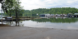
Wisdom Dock employee J.T. Hardin told the Clinton County News on Monday afternoon, that although the high water level was causing them plenty of problems, they had been able – so far – to work through most of them and remain open despite the high water.
“We’re open for business, and from what I’m hearing, we’re one of the few marinas (on Dale Hollow) that is still able to say that,” Hardin said. “All four of our walkways are under water, and we’ve built a bridge on top of one walkway leading to the marina store.”
Hardin said that the marina would do everything possible to continue to stay in an “open for business” status, and had plans in place to utilize a couple of barges to serve as walkways if necessary should the water continue to rise.
“Looking at the national weather outlook, we’ve got a bunch of rain headed this way, I just hope it goes above or below us,” Hardin said. “If it don’t, we’re going to be in bad shape.”
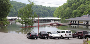
At Wolf River Marina, also on Dale Hollow, the high water was completely covering all of the parking available there, with the exception of the spaces around the restaurant and hotel/office building.
In addition, a ramp that had been put in place that allows access to the marina store and some of the private slips, was in place over water that was several feet above the roadway that leads to the campground and lower launch ramp.
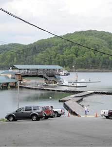
Over at Lake Cumberland, water is also high, but it was causing somewhat of a different reaction from Grider Hill Marina General Manager Rick Mercader.
For the past several years, the U.S. Army Corps of Engineers has worked to keep the level at Lake Cumberland at 680 feet above sea level, which is some 40 feet below summer pool levels, while construction crews at Wolf Creek Dam work to repair several leaks in that concrete and earthen structure.
“Actually, we’re about a foot above what would be considered ‘normal’ for this time of year,” Mercader said Monday afternoon as he left the marina area at the end of a day.
As of Tuesday at 12:00 noon, the U.S. Army Corps of Engineers was listing the level of Dale Hollow Lake at 659.08 feet above sea level.
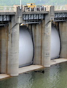
That level represents water that is just inches short of flowing over the top of the flood gates at the Dale Hollow Dam located at Celina, Tennessee.
On Monday afternoon, U.S. Army Corps of Engineers Public Affairs Specialist Lee Roberts of the Nashville District office, told the Clinton County News that the previous recorded high water level for Dale Hollow Lake had been 660.98 set in March, 1975.
In May, 1984, the level at Dale Hollow approached that record level but fell just short, reaching a msl (mean sea level) of 660.22.
The Corps of Engineers lists the height of the top of the floodgates for the Dale Hollow Dam at Celina, Tennessee, to be at 661 feet above sea level.
Last year, in the days that followed the torrential rainfalls that resulted in the mass flooding of downstream Cumberland River, in the region of Nashville, Tennessee and beyond, the Corps recorded a level of 657.34 as the high mark for 2010, occurring on May 5.
The Obey River, which forms Dale Hollow Lake beginning at the dam at Celina, Tennessee, flows into the Cumberland River about two miles downstream from the Dale Hollow Dam.
At Lake Cumberland, Monday morning’s level was listed as being 721.71 feet above sea level, which is just shy of what is considered “normal summer pool” level of 723 feet. The tree line at Lake Cumberland is considered to be 725 feet.
In a press release issued to the Clinton County News last week, the Corps of Engineers public affairs officer Bill Peoples explained some of the processes the agency is going through to manage the conditions throughout the Cumberland River Basin.
“The U.S. Army Corps of Engineers Nashville District Water Management staff continues to monitor stream conditions throughout the Cumberland Basin and to manage the release of water from dams within the basin,” Peoples noted in last week’s release.
“U.S. Army Corps of Engineers water management operations for the Cumberland Basin reservoir system are solely focused on reducing flood impacts on the lower Ohio and Mississippi Rivers where a flood of historic magnitude is underway. To this end, releases from Barkley Dam have been reduced significantly, and additional reductions are planned, to keep that water out of the Ohio River when the flood crest passes through the lower Ohio River reach,” the release continued. “In order to support this operation, which is being directed by Corps of Engineers water managers at the Great Lakes and Ohio River Division Office in Cincinnati, Ohio, releases from many of the projects managed locally by the Nashville District have been greatly reduced, and in some cases, discontinued completely.”
Peoples noted that Dale Hollow and Wolf Creek were just two of the four dams in the system that has seen altered water release rates due to the heavier than normal spring rains experienced in the past several days.
“Nashville District water managers initiated actions on Monday (April 26) to position the Cumberland system to respond to anticipated heavy rainfall within the basin and to be prepared to support the Ohio and Mississippi River flood control operation. Flows from the four large tributary projects (Wolf Creek, Center Hill, Dale Hollow and J. Percy Priest) within the Cumberland Basin have been reduced to extremely low levels,” the press release noted. “This will result in a rise in their lake levels, and in some cases could reach levels that restrict access to the water and/or impact the operation of marinas and other commercial facilities at these projects. Likewise, flows through the Cumberland River from Celina, Tenn., to Barkley Dam in western Kentucky will also be reduced. However, this effect will be somewhat masked due to the large volume of runoff still in the river resulting from recent heavy rains.”
Heavy spring rains have caused abnormally high levels at both Dale Hollow Lake and Lake Cumberland in recent weeks, with rains continuing to fall across the region this week. In the top photo, most of the lower parking lot and three of the four pedestrian walkways at Wisdom Dock on Dale Hollow Lake are under water in this photo made Monday afternoon, while at Wolf River Marina, above, also on Dale Hollow, nearly all parking and access to the campground is completely under water.
Below left, Grider Hill Marina General Manager Rick Mercader can be seen leaving the walkway toward the old ramp as water levels on Lake Cumberland are currently at about what would be considered normal summer pool. Lake Cumberland has been kept at a much lower level – nearly 40 feet lower – for the past couple of years while construction work continues to repair leaks at Wolf Creek Dam. Below right, the water level at Wolf Creek Dam was just inches below the structure’s flood gates on Monday afternoon.